
COUNTY LIFE
Double-whammy storm covers central U.S. bringing possible winter weather
A two-part storm is set to deliver back-to-back hits of wintry messes to the central United States this week, seeing 2020 to the door with slippery roads and hazardous conditions.
As the first part of the double-barreled storm with snow and ice spreads its wintry mix and travel disruptions across the north-central U.S. into midweek, forecasters are warning of a new round of snow and ice. The second round is expected to unfold over Texas before spreading northward and hitting some areas of the Plains and Upper Midwest with another dose of freezing and frozen precipitation prior to the end of the week. https://playlist.megaphone.fm/?e=ADL5474698738
A swath of heavy snow and ice from the first part of the storm will continue to advance northeastward from Kansas, Missouri, Nebraska and Iowa into Tuesday afternoon before taking aim at northern Illinois, Minnesota, Wisconsin and Michigan during Tuesday night and early Wednesday.

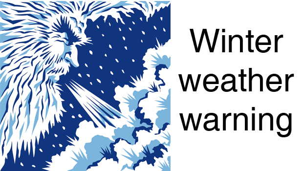
This radar image was captured around noon CST, Tuesday, Dec. 29, 2020. Snow is visible as blue, Ice is depicted as shades of purple and pink and rain is shown in green, yellow and orange. (AccuWeather)
The snowy part of the storm has made for dangerous travel conditions in parts of Colorado.
Interstate 76 in the northeastern part of the state was closed in both directions due to adverse weather during early Tuesday morning, according to the Colorado Department of Transportation.
Farther east, an icy and slippery commute affected motorists around Kansas City, Missouri, into Tuesday afternoon, but it is snow that is forecast to pile up with enough to shovel and plow around Omaha, Nebraska; Des Moines, Iowa; and Sioux Falls, South Dakota into the evening hours.

A period of snow is forecast to swing across Chicago and Milwaukee during Tuesday evening and may catch some people on their way home from work or school. The same burst of snow will move across the Detroit area, but it will not be until the late evening or overnight hours Tuesday. During the morning drive on Wednesday, snow will change to a brief period of ice around the Motor City, which can make for an especially dicey commute.
CLICK HERE FOR THE FREE ACCUWEATHER APP
After depositing 6-12 inches of snow with locally higher amounts on Colorado, the strip of heavy snow from the first part of the storm is expected to set up over northeastern Nebraska and northern Iowa and extend to southern Wisconsin. An AccuWeather StormMax™ of 20 inches is forecast for the first part of this storm.

“A more dangerous component of the storm will be a glaze of ice that has the potential to accrue to thicknesses that can not only weigh down trees limbs, but also lead to power outages from northern Kansas to northern Missouri, southeastern Iowa and part of western Illinois,” According to AccuWeather Senior Storm Warning Meteorologist Eddie Walker.
“In this zone that extends from the central Plains to part of the Mississippi Valley, between 0.25 and 0.50 of an inch of ice is expected to build up with an AccuWeather Local StormMax of 0.75 of an inch,” Walker said.
Typically, storms of this nature produce a single dose of snow and ice, and move on. However, that won’t be the case this time, as the encore of the storm will bring another messy mix.
Another disturbance in the jet stream is forecast to roll in from the Southwestern states as moisture lingers over the South Central region of the nation, triggering a new round of snow, ice and rain that will blossom over Texas Wednesday and roll northward spanning Wednesday night, Thursday and Friday over the Plains, Mississippi Valley and Midwest.

The second round of snow is forecast to begin much farther south than the first with portions of northern Mexico and southwestern Texas to experience a significant accumulation.
“Places such as San Angelo, Texas, only pick up 2-3 inches of snow per year, on average, but this storm can deliver that amount all in one shot,” Walker said.

Abilene, Texas, is another city that may receive close to its seasonal average for snowfall with this single storm. A close call between some snow and ice is forecast for Oklahoma City during Thursday night, after the first part of the storm brings rain and thunderstorms into Tuesday night.
Farther north, the swath of snow and ice is expected to overlap areas that have been or will be hit by wintry precipitation from the first part of the storm.
Most areas from the lower Great Lakes to the Ohio and lower Mississippi Valley will remain on the warm side of both parts of the storm with rounds of rain in store. However, there is expected to be a period of ice that can glaze roads and sidewalks for a second time in 48 hours.

Take time to remember all those who gave all for our freedoms in America. The Bowie News staff wishes you a safe and happy holiday day weekend this Memorial Day. The News office will be closed on Monday for the holiday.

AUSTIN – With Memorial Day weekend marking the unofficial start to summer boating season, Texas Game Wardens are preparing for one of the busiest boating weekends of the year and reminding Texans and visitors alike to put safety first before heading out on the water.
In 2025, Texas recorded 178 reportable boating incidents that resulted in 50 fatalities and 77 serious injuries. Eighty-four percent of those who died in boating incidents were not wearing a life jacket. Texas Game Wardens also made 223 Boating While Intoxicated (BWI) arrests last year.
“Memorial Day weekend is when many families get back on the water for the first time this year,” said Col. Ron VanderRoest, director of Law Enforcement for the Texas Parks and Wildlife Department. “Before you leave the dock, take a few minutes to make sure your life jackets are on board, your boat is properly equipped and you have designated a sober operator.”
Texas Game Wardens encourage boaters to keep the following in mind before launching:
- Wear a U.S. Coast Guard-approved life jacket. Children younger than 13 are required to wear one while underway.
- Never operate a boat under the influence of alcohol or drugs.
- The operator must wear the lanyard or have the engine cut-off switch fob on their person when operating a boat equipped with one.
- Operate at a safe speed and maintain a proper lookout.
- Take a boater education course. It is required for anyone born on or after Sept. 1, 1993.
- Check the weather before heading out and be prepared for changing conditions.
- Leave a float plan with someone you trust.
- Don’t overload your boat.
“Boating should be fun,” said VanderRoest. “A little planning and some common sense help keep it that way.”
Renting a Boat or Personal Watercraft
If you plan to rent a boat or personal watercraft, choose a licensed vessel livery (a business establishment engaged in renting or hiring out vessels for profit).
By law, vessel liveries must provide all required safety equipment, explain how to operate the vessel, review applicable boating laws and have the operator sign a form acknowledging they received this information. They are also required to carry liability insurance.
Before leaving the dock, renters should make sure the vessel has enough life jackets for everyone on board and that they understand basic operating rules, including those specific to personal watercraft.
Personal Watercraft Safety
Personal watercraft, including jet skis, are subject to special laws in Texas. Operators and passengers must always wear a life jacket, the operator must use the engine cut-off switch, and these vessels may not be operated between sunset and sunrise. Operators must also stay at least 50 feet from other vessels, people and the shore unless traveling at headway speed.
“Whether you’re launching your own boat or renting one for the day, take the time to understand the rules and make safety part of your plan,” said VanderRoest. “If you take safety seriously from the start, you’re far less likely to need help later.”
For more information about boating laws, required equipment and boater education courses, visit the TPWD Boater Education Program at tpwd.texas.gov/boatereducation.

Starting at noon on May 25 at The V (VFW) in Nocona there will be a program for the Memorial Day featuring speakers, cannons and a rifle team.
There will be a Memorial Day Celebration Dinner at 5 p.m. on May 25 at the Nocona Senior Citizens Center (Carpenter Shop).
Call for reservations at 940-825-3148. The meal will include barbecue ribs, french fries, beans, cole slaw, dessert and ice team. Adults are $10 and children $5.
Proceeds benefit the senior center and the Meals on Wheels program at Nocona.


-

 NEWS3 years ago
Suspect indicted, jailed in Tia Hutson murder
-
 NEWS4 years ago
2 hurt, 1 jailed after shooting incident north of Nocona
-
 NEWS3 years ago
SO investigating possible murder/suicide
-
 NEWS3 years ago
Wreck takes the life of BHS teen, 16
-

 NEWS3 years ago
Murder unsolved – 1 year later Tia Hutson’s family angry, frustrated with no arrest
-
 Show us something good9 years ago
Country music star children perform in Bowie
-
NEWS3 years ago
Sheriff’s office called out to infant’s death
-
 100th Birthday4 years ago
Looking back at the 1958 Centennial edition of The Bowie News