
NEWS
Next big storm to target central U.S. with variety of hazards
By Renee Duff, AccuWeather meteorologist
Updated jan. 13, 2020 11:08 AM
A winter storm brought strong winds to this lakeshore in Chicago, Illinois, on Jan. 11. Wind gusts of 50 mph fueled waves as high as 23 feet as they slammed ashore.
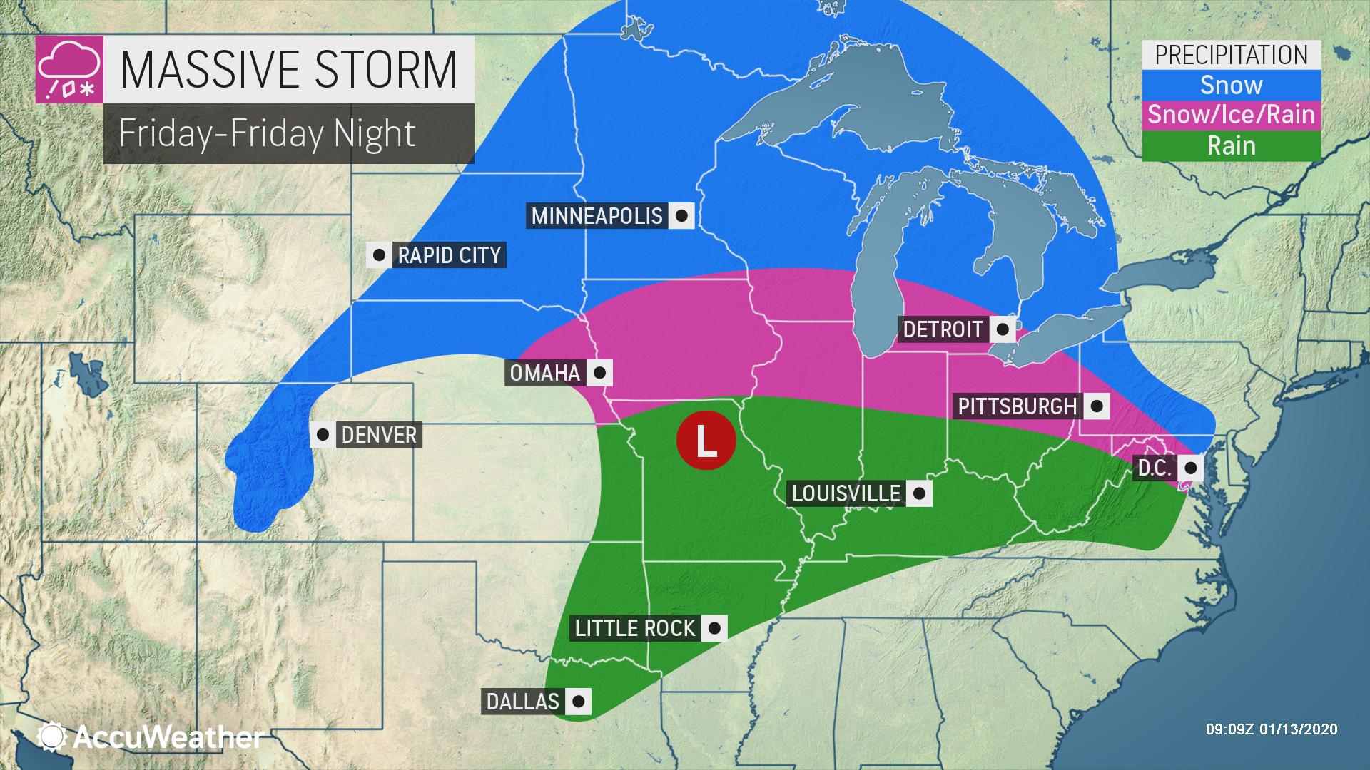
Forecasters are monitoring what they say will be the next multifaceted storm to target the central United States at the end of the week. The storm is expected to bring a variety of hazards to travelers as precipitation will vary from rain to ice to snow amid the midsection of the nation.
Prior to late week, motorists will also need to be wary of several quick-hitting snow events that will sweep through the Midwest.

The late-week storm will first bring accumulating snowfall to places such as Seattle and Portland, Oregon, as well as some rain and snow to California Wednesday into Thursday, before it reaches the Central states on Friday.
Slippery travel conditions to threaten northern Plains to Great Lakes, Ohio Valley
A fresh wave of bitterly cold air will arrive in the North Central states on Thursday ahead of the storm, which will lay the groundwork for a large corridor to face wintry weather and slippery travel once precipitation arrives.
“At this time, we expect many of the major metro areas of the Midwest to face messy commutes both Friday morning and evening,” AccuWeather Meteorologist Mary Gilbert said.
Large stretches of interstates 29, 35, 80, 90 and 94 are expected to lie within a broad area of snow and ice, making for difficult travel conditions.

In some parts of the central Plains, Ohio Valley and Great Lakes, the onset of the storm may feature all snow before a changeover to ice occurs. Where precipitation remains all snow, amounts could easily surpass half a foot.
Enough snow to shovel, plow and disrupt daily routines is possible in Fargo, North Dakota; Minneapolis and Duluth, Minnesota; Green Bay, Wisconsin; and Marquette and Traverse City, Michigan.
Increasing wind with the snow could lead to reduced visibility and localized blizzard conditions as the storm strengthens, according to AccuWeather Senior Meteorologist Matt Rinde.
Slightly farther south – where a layer of warmer air will flow in a few thousand feet above the ground – precipitation can be icy with sleet and freezing rain possible.
“Icing will be a major concern with this storm and untreated surfaces will become treacherous,” Rinde said.
At this juncture, a corridor from eastern Nebraska through portions of Iowa, Illinois, Indiana, Ohio and southern Michigan could see icy conditions. How quickly cold air is rooted out of Kansas City and St. Louis, Missouri, will determine whether icy conditions develop in these metro areas or precipitation arrives in the form of plain rain.
The Friday evening commute in Chicago could be a wintry mess with a chance for snow and ice, depending on the exact track and speed of the storm.
“Bitter cold to follow the storm will cause any areas of snow and slush to freeze,” Rinde said.
As the exact path of the storm becomes clearer in the coming days, the corridor of heaviest snow and ice may shift to the north and west or south and east. AccuWeather will continue to provide these details as they unfold.
Rain, thunderstorms may once again elevate flood concerns in southern Plains
The late-week storm will feature all rain for places such as Dallas, Oklahoma City and Little Rock, Arkansas, cities that were pounded by deadly severe weather last week.
AccuWeather meteorologists cannot rule out the potential for some severe thunderstorms to rumble through this corridor from Friday into Friday night, but a repeat of last week’s outbreak is not expected.
The biggest concern may come in the form of downpours that can reduce visibility for motorists and trigger flash flooding.
Forecasters will be closely monitoring the storm as it shifts into the Northeast by the weekend, with snow, ice, rain and gusty winds all possibilities.
Keep checking back on AccuWeather.com and stay tuned to the AccuWeather Network on DirecTV, Frontier and Verizon Fios.
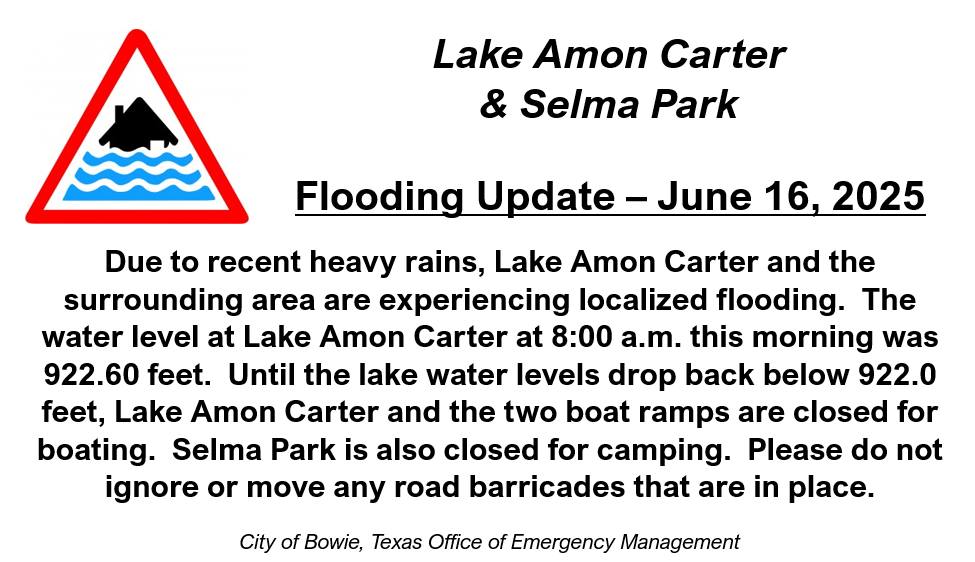
Members of the Bowie Independent School District Board of Trustees will meet at 5:30 p.m. on June 16.
The big item on the agenda is the review of superintendent candidate applications and consider possible interview choice. Superintendent Blake Enlow resigned on May 23 and Assistant Superintendent Lee Ann Farris has been serving as the interim.
That item will be in executive session along with professional educator contracts that need to be considered.
On the regular agenda Farris will update the board on education bills passed by the 89th Texas Legislature and their budget impacts, as well as discipline impacts. A budget workshop will be considered. She also will provide information on state assessment and board goals.
Campus administrators and directors will provide updates, along with the finance director.
In action items the board will review Texas Association of School Board update 124, consider changes to the 12-month and 11 employee dates and consider the purchase of a new band trailer not to exceed $80,000.

Due to the June 19 Juneteenth federal holiday the U.S. Post Office will be closed, which moves then Thursday Bowie News to a delivery date on Friday. It will be available in the stores at its regular time.


-
 NEWS3 years ago
2 hurt, 1 jailed after shooting incident north of Nocona
-

 NEWS2 years ago
Suspect indicted, jailed in Tia Hutson murder
-
 NEWS2 years ago
SO investigating possible murder/suicide
-

 NEWS2 years ago
Wreck takes the life of BHS teen, 16
-

 NEWS2 years ago
Murder unsolved – 1 year later Tia Hutson’s family angry, frustrated with no arrest
-
NEWS2 years ago
Sheriff’s office called out to infant’s death
-
 NEWS2 years ago
Bowie Police face three-hour standoff after possible domestic fight
-
NEWS3 years ago
Driver stopped by a man running into the street, robbed at knifepoint