
NEWS
Increased fire danger anticipated today
I
COLLEGE STATION, Texas—Texas A&M Forest Service readies firefighting resources today in anticipation of an increase in wildfire activity caused by pre-frontal conditions approaching the state.
The fire environment will include elevated to critical fire weather, with above normal temperatures and wind speeds near 20 mph, aligned with freeze-cured grasses across the landscape. This combination will support increased wildfire activity.
Forecast fire danger will be high to very high for portions of the Rolling Plains and Cross Timbers regions, specifically for areas around Plainview, Wichita Falls, Weatherford, Lampasas and San Angelo.
State and local firefighters, including Texas A&M Forest Service and Texas Intrastate Fire Mutual Aid System (TIFMAS), responded to 97 wildfires since Friday morning for an estimated 7,460 acres burned.
Strong north winds and dry vegetation contributed to increased activity over the weekend, which included the 1,696-acre Mill Creek Fire in Shackelford County, the 787-acre Martin Fire in Young County and the 177-acre Carbon Camp Fire in Hutchinson County.
In anticipation of increased fire danger on Tuesday, Texas A&M Forest Service has prepositioned additional agency personnel and equipment, including 11 dozers and four engines, across areas of concern.
“Any time the forecast indicates that there is potential for wildfire activity, we mobilize resources to strategic locations to provide assistance to local fire departments and cooperators,” said Wes Moorehead, Texas A&M Forest Service Fire Chief.
Texas A&M Forest Service and Texas Division of Emergency Management worked together to mobilize two strike teams via TIFMAS to provide wildfire incident support prior to this weekend’s increased activity.
“We greatly appreciate our state, federal and local partners that continue to diligently work together to protect Texas’ citizens and natural resources from wildfire,” said Moorehead.
Two large airtankers, three single engine air tankers, two air attack platforms and one aerial supervision module remain in state to assist with wildfire response efforts.
Texas A&M Forest Service encourages the public to avoid outdoor activities that may cause a spark while dry and windy conditions are present.
For current conditions and wildfire outlook, visit the Texas Fire Potential Outlook https://bit.ly/3kemhbG.

The Bowie City Council will meet at 6 p.m. on June 23.
The agenda includes both old and new business items.
City Manager Bert Cunningham will make his report on the 2026-27 budget process, bid opening for the Glenn Hills lift station on July 16 and the bid for Rock and Pillar repairs.
In new business a pair of planning and zoning committee recommendations for replats at 107 E. Nelson and 412 Green will be reviewed. An ordinance adopting an office of emergency management amending a present ordinance will be offered.
Old business will see the second reading of the pickleball court reservation fee ordinance and the ordinance prohibiting drilling and mining or the reopening of an abandoned well or mine in any public park in the city limits.

A HEAT ADVISORY will be in effect from noon until 9 p.m. today (Thursday). Please plan accordingly.
Hear Audio Alert:https://hrpow.us/oeFZANN
Montague County Sheriff Marshall Thomas has confirmed human skeletal remains were recovered on June 13 in the Sunset area, and they could possibly be those of a flight attendant believed to have been murdered almost a year ago in the Fort Worth.
The murder suspect, Dennis William Day, 66, admitted in June 2025 to strangling Rana Soluri, 47, an Envoy flight attendant who lived with Day during that last year. She was reported missing by a co-worker on June 11 and had not been seen or heard from since March 2025.
Day initially denied any involvement, but later admitted to the murder and indicated he dumped her body somewhere in the Montague County area. Lawmen have scoured the areas in questions in both Montague and Wise County, but found nothing.
Sheriff Thomas said on June 13 the SO received a call of possible skeletal remains in the Brushy Creek area north of Poss Dyer Lane on Farm-to-Market 1749. A deputy went to the scene and confirmed it was human remains.
Investigators responded and kept the scene secure overnight until staff from the University of North Texas Forensic Anthropology Center could arrive and made the recovery on June 14. A Texas Ranger and staff from the Fort Worth Police Department also were on scene.
“There is no determination made yet on how long it has been there,” said Thomas. “The anthropologist was pleased to recover most of the skeleton in these conditions. Heavy rains previously made the past searches difficult. We are working jointly with Fort Worth to make an identification and if it is the victim in their homicide.”


-

 NEWS3 years ago
Suspect indicted, jailed in Tia Hutson murder
-
 NEWS4 years ago
2 hurt, 1 jailed after shooting incident north of Nocona
-
 NEWS3 years ago
SO investigating possible murder/suicide
-
 NEWS3 years ago
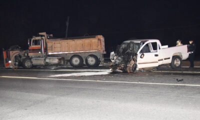
Wreck takes the life of BHS teen, 16
-

 NEWS3 years ago
Murder unsolved – 1 year later Tia Hutson’s family angry, frustrated with no arrest
-
 Show us something good9 years ago
Country music star children perform in Bowie
-
NEWS3 years ago
Sheriff’s office called out to infant’s death
-
 100th Birthday4 years ago
Looking back at the 1958 Centennial edition of The Bowie News