
COUNTY LIFE
Stormy weather expected Friday and Saturday in the south

Americans across the southern United States are next in line for the threat of another outbreak of damaging storms heading into the weekend. AccuWeather meteorologists warn that people living in states from Texas to Georgia could be at risk for severe weather from late Friday night through Saturday night as a storm system progresses eastward.
Seven preliminary tornadoes were reported with the storms that erupted on Wednesday and Wednesday night, four of which occurred in Louisiana and caused damage to homes, according to the National Weather Service Storm Prediction Center (SPC). Dozens of incidents of damaging wind gusts, along with a few incidents of hail, stretched from eastern Texas northward to southern Wisconsin.
On the southwestern side of Cedar Rapids, Iowa, a tornado caused damage to homes and at least one injury. According to the NWS, the tornado was given a preliminary rating of EF0 and had wind speeds as high as 85 mph.
An EF0 tornado with maximum winds of 75 mph touched down briefly in Hancock County, Mississippi, moving northeastward and creating a .7 mile-long path with a width of 50 yards.
Remnants of the storms from Wednesday night pushed through the Interstate 10 and 20 corridors of Louisiana, Mississippi, Alabama, and the Florida Panhandle on Thursday morning.
As storms rolled through the New Orleans area early Thursday, a tornado warning was issued due to some indication of rotation on radar. While no tornado was confirmed, storms dumped between 2.40 and 2.70 inches of rain on the Big Easy in four hours.

By Thursday night, storms with big hail erupted over portions of central and eastern Texas, causing significant damage to vehicles. Hail as large as baseballs was reported in College Station.
Many of these same areas will be in the crosshairs of a new round of severe weather for the end of the week.

Areas extending from the southern Appalachians to the central Gulf coast are at risk for severe weather, according to AccuWeather Senior Storm Warning Meteorologist Eddie Walker.
The main threats from these storms in addition to flooding downpours are likely to be damaging wind gusts and hail.
The storms are expected to erupt near the edge of a zone of very warm air that could lead to some daily record highs being challenged in Texas on Friday. Temperatures are projected to climb into the 80s and 90s F over a broad area of Texas. A few locations, such as San Antonio, may come within a few degrees of 100 F.
“There is the potential for a derecho event during Friday night from parts of northeastern Texas and eastern Oklahoma to portions of Louisiana and Arkansas,” AccuWeather Lead Storm-Warning Meteorologist William Clark said. Should a derecho unfold, its path may eventually take it through Mississippi and Alabama early Saturday morning.
A derecho is a swift-moving complex of thunderstorms that produces extensive wind damage over hundreds of miles.
“With a fresh influx of Gulf of Mexico moisture in the form of humid air, combined with wind energy at the middle layer of the atmosphere associated with the approaching disturbance, the ingredients are there for severe weather from late Friday through Saturday,” AccuWeather Senior On-Air Meteorologist Justin Povick said. https://playlist.megaphone.fm/?e=ADL4348958722
The coverage and intensity of severe weather may hinge on the amount of sunshine available.
“Part of the atmospheric environment on Friday and Saturday may be strewn with clouds that limit daytime heating in part of the area at risk for severe weather, but where the sun breaks out, tall storms can erupt and pack a punch,” AccuWeather Chief On-Air Meteorologist Bernie Rayno said.
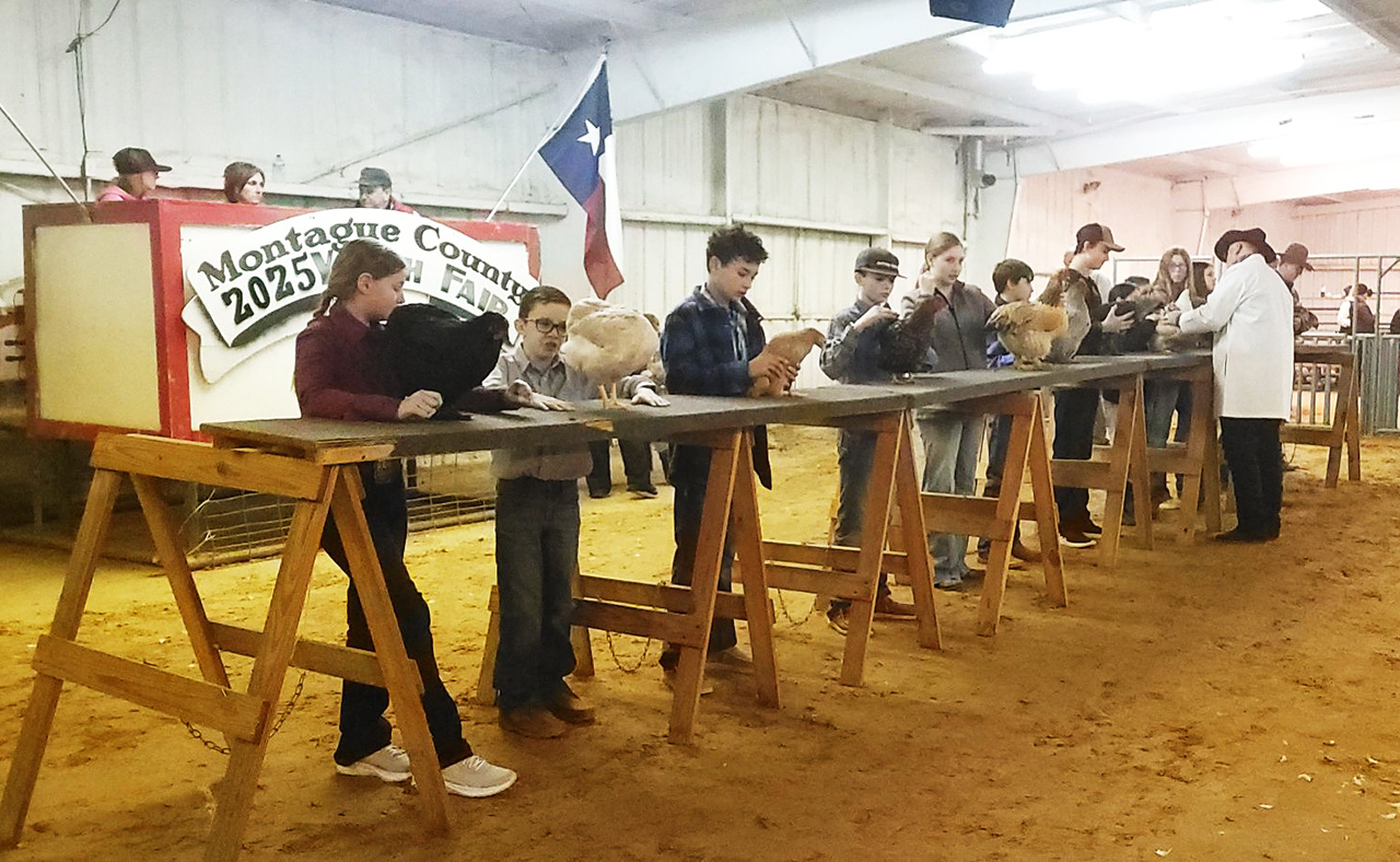
It has been quite a busy few days at the Montague County Youth Fair with schedule changes, juggling of events and trying to cope with the unexpected snow storm. However, the youth fair always rolls on thanks to the dedicated volunteers, coordinators, parents and students.
Friday the rabbit how starts at 10 a.m., with heifer and steer show at 2 p.m. Ag. mech. check-in at 6 p.m. with that show at 9 a.m. on Saturday. Swine will move into the barn later today with its show at 9 a.m. Saturday.
Saturday the home economics silent auction will start at 6 p.m. and run to 9 p.m. in the show barn. Showmanship buckles will be presented at 6 p.m. in the barn followed by leadership day awards. The premium sale is at 6:30 p.m. Make plans to come out and support these hard working kids and families.
See all the winners in the Thursday Bowie News.
Top photo – Poultry show photo taken by Rashonda Hobbs of Unfazed Creations, official photographer for the youth fair. Make sure and check out her photos.


When we were going through my grandmother’s house in Nocona after it sold, I found a few neat keepsakes, but the biggest treasure I thought I had found was her biscuit cutter. I was so excited to show my mother (her daughter) and just knew she would be happy it was found and would still be used after all this time.
My mother, however, had a different thought about my precious biscuit cutter. She said, “Suzanne, you know that biscuit cutter is just an old tomato paste can that has both ends cut out.”
I was still no less delighted with my cutter. I continue to use it today. My husband has bought me vintage, new and fancier cutters, but this cutter is something I go back to time and again.
My Memaw was recruited to be a lunch lady from 1952 to 1958 at Nocona Elementary, back when lunches were cooked, not “fixed.” Lenora Brown Burnett was an excellent cook and everyone knew it. She went on to work at the Nocona Major Clinic kitchen from 1958 to 1969.
You could only use shortcuts if you knew how to do it the long way. That is how I still approach cooking. You can only use a cake mix if you know how to make a cake with lots of ingredients, time and effort.
Read Suzanne’s Love & Luck column in the Thursday Bowie News on the On the Table page.
Top photo – Grandmother’s biscuit cutter and hand written recipes. (Photo by Suzanne Storey)


-
 NEWS2 years ago
2 hurt, 1 jailed after shooting incident north of Nocona
-

 NEWS1 year ago
Suspect indicted, jailed in Tia Hutson murder
-
 NEWS2 years ago
SO investigating possible murder/suicide
-

 NEWS2 years ago
Wreck takes the life of BHS teen, 16
-

 NEWS1 year ago
Murder unsolved – 1 year later Tia Hutson’s family angry, frustrated with no arrest
-
NEWS2 years ago
Sheriff’s office called out to infant’s death
-
 NEWS2 years ago
Bowie Police face three-hour standoff after possible domestic fight
-
NEWS2 years ago
Driver stopped by a man running into the street, robbed at knifepoint