
NEWS
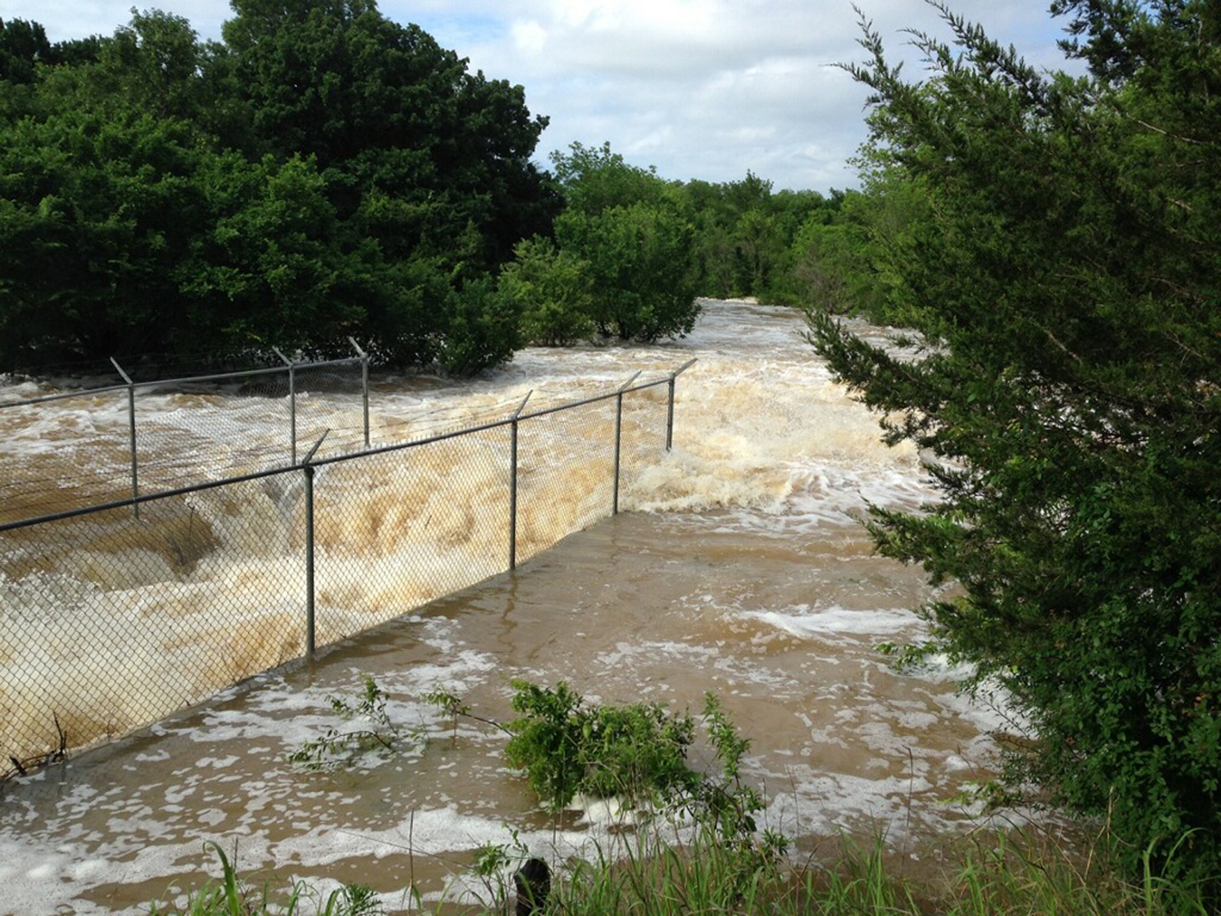
Where does all that water go? Lake Amon Carter design is working like it is suppose too
By BARBARA GREEN
More than 150,000 gallons of water a minute are flowing out of Lake Amon G. Carter’s spillway as the lake’s overflow above 920 mean sea level heads south downstream toward Eagle Mountain Lake and other stops in the Trinity River Basis.
During the last two weeks more than 12 inches of rain have fallen on the Bowie area, helping fill Lake Amon Carter. At the maximum the lake topped 927.42 on May 11, 7.42 feet above its capacity at 920.
City of Bowie officials have been taking heat from residents around Lake Amon Carter whose homes were flooded from rising lake waters, heavy rainfall or run-off. They are upset about damaged docks and retaining walls, and in other instances water coming into their homes causing damage.
Persons with flood damage can contact the American Red Cross, which was in town during the stormy weekend. The disaster assistance team may be able to help. Call 325-677-2622. Read more about the high water and how Lake Amon Carter is designed to handle it in the Saturday News. By

The Bowie City Council will meet at 6 p.m. on June 23.
The agenda includes both old and new business items.
City Manager Bert Cunningham will make his report on the 2026-27 budget process, bid opening for the Glenn Hills lift station on July 16 and the bid for Rock and Pillar repairs.
In new business a pair of planning and zoning committee recommendations for replats at 107 E. Nelson and 412 Green will be reviewed. An ordinance adopting an office of emergency management amending a present ordinance will be offered.
Old business will see the second reading of the pickleball court reservation fee ordinance and the ordinance prohibiting drilling and mining or the reopening of an abandoned well or mine in any public park in the city limits.

A HEAT ADVISORY will be in effect from noon until 9 p.m. today (Thursday). Please plan accordingly.
Hear Audio Alert:https://hrpow.us/oeFZANN
Montague County Sheriff Marshall Thomas has confirmed human skeletal remains were recovered on June 13 in the Sunset area, and they could possibly be those of a flight attendant believed to have been murdered almost a year ago in the Fort Worth.
The murder suspect, Dennis William Day, 66, admitted in June 2025 to strangling Rana Soluri, 47, an Envoy flight attendant who lived with Day during that last year. She was reported missing by a co-worker on June 11 and had not been seen or heard from since March 2025.
Day initially denied any involvement, but later admitted to the murder and indicated he dumped her body somewhere in the Montague County area. Lawmen have scoured the areas in questions in both Montague and Wise County, but found nothing.
Sheriff Thomas said on June 13 the SO received a call of possible skeletal remains in the Brushy Creek area north of Poss Dyer Lane on Farm-to-Market 1749. A deputy went to the scene and confirmed it was human remains.
Investigators responded and kept the scene secure overnight until staff from the University of North Texas Forensic Anthropology Center could arrive and made the recovery on June 14. A Texas Ranger and staff from the Fort Worth Police Department also were on scene.
“There is no determination made yet on how long it has been there,” said Thomas. “The anthropologist was pleased to recover most of the skeleton in these conditions. Heavy rains previously made the past searches difficult. We are working jointly with Fort Worth to make an identification and if it is the victim in their homicide.”


-

 NEWS3 years ago
Suspect indicted, jailed in Tia Hutson murder
-
 NEWS4 years ago
2 hurt, 1 jailed after shooting incident north of Nocona
-
 NEWS3 years ago
SO investigating possible murder/suicide
-

 NEWS3 years ago
Wreck takes the life of BHS teen, 16
-

 NEWS3 years ago
Murder unsolved – 1 year later Tia Hutson’s family angry, frustrated with no arrest
-
 Show us something good9 years ago
Country music star children perform in Bowie
-
NEWS3 years ago
Sheriff’s office called out to infant’s death
-
 100th Birthday4 years ago
Looking back at the 1958 Centennial edition of The Bowie News